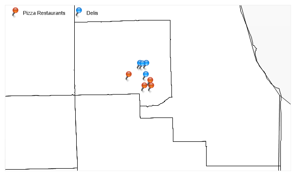
POIMap
Demonstrates adding points of interest icons onto a map based on GPS coordinates.
<%@ Page Language="C#" Description="dotnetCHARTING Component" %>
<%@ Register TagPrefix="dotnet" Namespace="dotnetCHARTING" Assembly="dotnetCHARTING"%>
<%@ Import Namespace="System.Drawing" %>
<%@ Import Namespace="System.Drawing.Drawing2D" %>
<%@ Import Namespace="dotnetCHARTING.Mapping" %>
<script runat="server">
void Page_Load(Object sender,EventArgs e)
{
// Demonstrates adding points of interest icons onto a map based on GPS coordinates.
Chart.TempDirectory = "temp";
Chart.Debug = true;
Chart.Type = ChartType.Map;
Chart.Size = "600x350";
//Chart.Title = ".netCHARTING Sample";
Chart.ChartArea.Background.Color = Color.FromArgb(248, 248, 248);
Chart.LegendBox.Position = LegendBoxPosition.ChartArea;
Chart.Mapping.ZoomCenterPoint = new PointF(41.75f, -88);
Chart.Mapping.ZoomPercentage = 7500;
MapLayer layer = MapDataEngine.LoadLayer("../../images/mapFiles/primusa.shp");
layer.DefaultShape.Background.Color = Color.White;
Chart.Mapping.MapLayerCollection.Add(layer);
Chart.Mapping.MapLayerCollection.Add("../../images/mapFiles/co17_d00.shp");
MapLayer pizza = new MapLayer();
ElementMarker pizzaMarker = new ElementMarker("../../images/pin_red.png");
pizza.AddLatLongPoint(new PointF(41.75f, -87.99f), pizzaMarker);
pizza.AddLatLongPoint(new PointF(41.79f,-88.07f ), pizzaMarker);
pizza.AddLatLongPoint(new PointF(41.75f, -88.015f), pizzaMarker);
pizza.AddLatLongPoint(new PointF(41.77f, -87.994f), pizzaMarker);
Chart.Mapping.MapLayerCollection.Add(pizza);
MapLayer deli = new MapLayer();
ElementMarker deliMarker = new ElementMarker("../../images/pin_blue.png");
deli.AddLatLongPoint(new PointF(41.79f, -88.01f), deliMarker);
deli.AddLatLongPoint(new PointF(41.83f, -88.03f), deliMarker);
deli.AddLatLongPoint(new PointF(41.83f, -88.008f), deliMarker);
deli.AddLatLongPoint(new PointF(41.829f, -88.022f), deliMarker);
Chart.Mapping.MapLayerCollection.Add(deli);
LegendEntry le = new LegendEntry("Pizza Restaurants","");
le.SeriesType = SeriesType.Marker;
le.Marker = pizzaMarker;
LegendEntry le2 = new LegendEntry("Delis","");
le2.SeriesType = SeriesType.Marker;
le2.Marker = deliMarker;
Chart.LegendBox.ExtraEntries.Add(le, le2);
Chart.LegendBox.Visible = true;
}
</script>
<html xmlns="http://www.w3.org/1999/xhtml">
<head><title>.netCHARTING Sample</title></head>
<body>
<div align="center">
<dotnet:Chart id="Chart" runat="server"/>
</div>
</body>
</html>
<%@ Page Language="vb" Description="dotnetCHARTING Component" %>
<%@ Register TagPrefix="dotnet" Namespace="dotnetCHARTING" Assembly="dotnetCHARTING"%>
<%@ Import Namespace="System.Drawing" %>
<%@ Import Namespace="System.Drawing.Drawing2D" %>
<%@ Import Namespace="dotnetCHARTING.Mapping" %>
<script runat="server">
Sub Page_Load(ByVal sender As Object, ByVal e As EventArgs)
' Demonstrates adding points of interest icons onto a map based on GPS coordinates.
Chart.TempDirectory = "temp"
Chart.Debug = True
Chart.Type = ChartType.Map
Chart.Size = "600x350"
'Chart.Title = ".netCHARTING Sample";
Chart.ChartArea.Background.Color = Color.FromArgb(248, 248, 248)
Chart.LegendBox.Position = LegendBoxPosition.ChartArea
Chart.Mapping.ZoomCenterPoint = New PointF(41.75f, -88)
Chart.Mapping.ZoomPercentage = 7500
Dim layer As MapLayer = MapDataEngine.LoadLayer("../../images/mapFiles/primusa.shp")
layer.DefaultShape.Background.Color = Color.White
Chart.Mapping.MapLayerCollection.Add(layer)
Chart.Mapping.MapLayerCollection.Add("../../images/mapFiles/co17_d00.shp")
Dim pizza As MapLayer = New MapLayer()
Dim pizzaMarker As ElementMarker = New ElementMarker("../../images/pin_red.png")
pizza.AddLatLongPoint(New PointF(41.75f, -87.99f), pizzaMarker)
pizza.AddLatLongPoint(New PointF(41.79f,-88.07f), pizzaMarker)
pizza.AddLatLongPoint(New PointF(41.75f, -88.015f), pizzaMarker)
pizza.AddLatLongPoint(New PointF(41.77f, -87.994f), pizzaMarker)
Chart.Mapping.MapLayerCollection.Add(pizza)
Dim deli As MapLayer = New MapLayer()
Dim deliMarker As ElementMarker = New ElementMarker("../../images/pin_blue.png")
deli.AddLatLongPoint(New PointF(41.79f, -88.01f), deliMarker)
deli.AddLatLongPoint(New PointF(41.83f, -88.03f), deliMarker)
deli.AddLatLongPoint(New PointF(41.83f, -88.008f), deliMarker)
deli.AddLatLongPoint(New PointF(41.829f, -88.022f), deliMarker)
Chart.Mapping.MapLayerCollection.Add(deli)
Dim le As LegendEntry = New LegendEntry("Pizza Restaurants","")
le.SeriesType = SeriesType.Marker
le.Marker = pizzaMarker
Dim le2 As LegendEntry = New LegendEntry("Delis","")
le2.SeriesType = SeriesType.Marker
le2.Marker = deliMarker
Chart.LegendBox.ExtraEntries.Add(le, le2)
Chart.LegendBox.Visible = True
End Sub
</script>
<html xmlns="http://www.w3.org/1999/xhtml">
<head><title>.netCHARTING Sample</title></head>
<body>
<div align="center">
<dotnet:Chart id="Chart" runat="server"/>
</div>
</body>
</html>